The Best Things to Do at the Great Smoky Mountains, Starting with the View from the Cabin
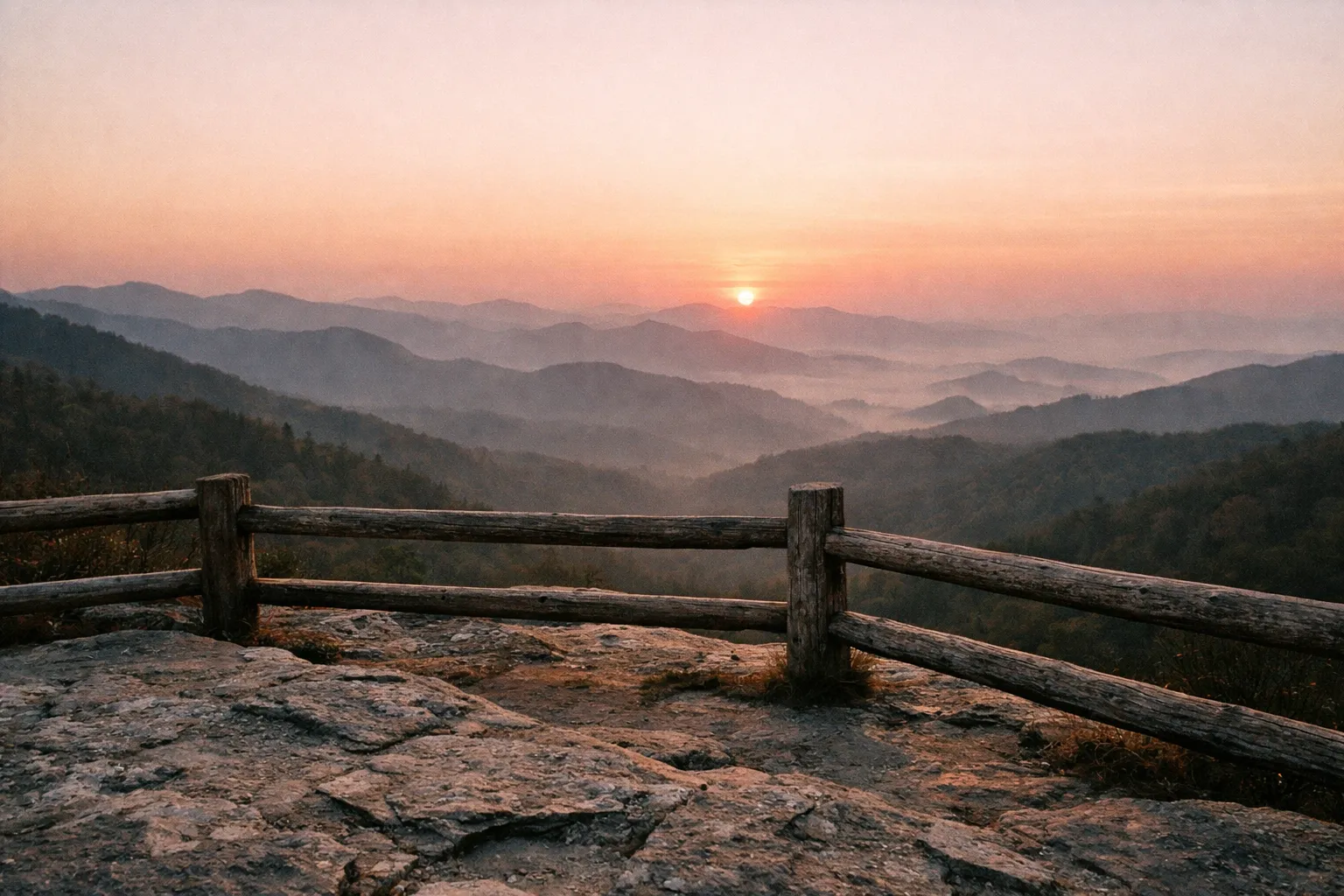
When planning your visit, the best things to do at the Great Smoky Mountains often begin with catching the sunrise at Clingmans Dome - now also called Kuwohi, its Cherokee name, which you’ll increasingly see on maps and signage (6).
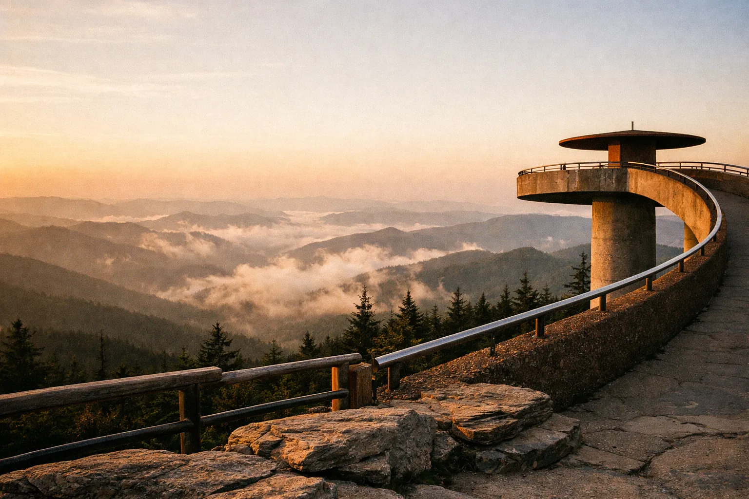
Clingmans Dome is the highest point in the park. At 6,643 feet, temperatures run significantly cooler than the rest of the park, especially before sunrise (1). I caught it from the parking area on one visit, which was still worth the drive.
One thing to know: this is the spot most often socked in by clouds. I’ve driven up to find a wall of fog and nothing else. Check the forecast or ask at a visitor center before committing to the 30-minute climb up the access road. If it’s fogged in, pivot to a lower river or waterfall hike where mist works in your favor instead of against you.
Kuwohi/Clingmans Dome Observation Tower: What the Walk Actually Gets You
After reaching the parking area, take the time to walk up to the observation tower. The trail is short and steep - a genuine early morning workout, not a stroll. The 360-degree view from the top is easily one of the best in the entire park.
The paved walk to the tower is half a mile each way and gains around 330 feet. Short, but don’t underestimate the grade. On a clear day, the view spans into seven states. Late fall and winter give you the cleanest long-range visibility, since summer humidity is what puts the “smoky” haze in the mountains (1).
Best month to visit: October is the practical answer - fall color peaks in mid-to-late October at mid-elevations, the humidity that blurs long-range views has dropped, and temperatures at 6,643 feet run in the 40s-50s F, which is cold enough to dress for but not punishing. Early June works if the firefly lottery is your target. Avoid July and August at the high overlooks unless you’re fine with haze cutting visibility to a few ridgelines.
How to get there: The park straddles the Tennessee-North Carolina border. From Knoxville, TN, it’s roughly 30 miles southeast on US-441 to the Sugarlands Visitor Center near Gatlinburg - about 45 minutes without traffic, longer on fall weekends. From Asheville, NC, take I-40 west to US-19 north to US-441 north through Cherokee; plan on 60-70 minutes. The nearest major airports are McGhee Tyson (TYS) in Knoxville (about 50 miles) and Asheville Regional (AVL) at roughly 60 miles. There is no public transit to the park - a rental car is not optional.
Total trip cost estimate: Budget $30/night for front-country camping (or $150-$400+/night for a Gatlinburg cabin), plus roughly $60-$100 in fuel for a 3-day loop hitting the main corridors, and a $5 parking tag if you stop at trailheads for more than 15 minutes. A 3-night camping trip for two runs $90-$150 all-in before food; a cabin-based trip runs $500-$1,200+ for the same duration.
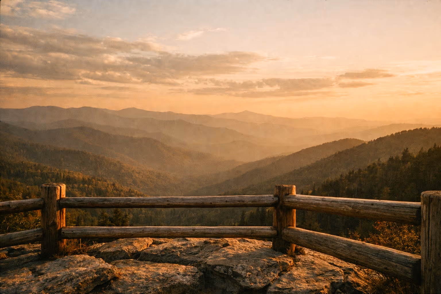
View from the Top of Clingmans Dome
If you want more views without much effort, drive Newfound Gap Road. The road covers 33 miles of scenery and overlooks, running from Gatlinburg all the way into Cherokee, North Carolina (US-441 is the main spine).
Various trails and campgrounds branch off this road, but the drive itself is worth doing for the overlooks alone. Worth the detour: stop at Newfound Gap itself, where the Appalachian Trail crosses the road, and at Ben Morton Overlook for fall foliage - locals point to it as a prime late-October spot with fewer crowds than Cades Cove (1).
Laurel Falls: Best Short Hike for Non-Hikers
For a short hike with a solid payoff, head to Laurel Falls. It’s one of the most popular trails in the park, and there were plenty of people there when I arrived - even mid-week. The hike is about 2.6 miles roundtrip and took me just over an hour.
The trail is paved, which makes it accessible to most fitness levels. That said, the pavement gets slick when wet, so wear shoes with actual grip rather than sandals or worn-out sneakers. The 80-foot falls at the end are worth it.
The trailhead sits on Little River Road, about 3.5 miles west of Sugarlands Visitor Center - easy to slot in before or after the Newfound Gap Road drive. Parking is limited; arrive before 9:00 a.m. on weekends or expect to wait for a spot. Worth the detour if you have non-hikers in the group. Skip if you’re already doing Alum Cave or Rainbow Falls the same day - the falls are smaller and the trail adds up.
Top 5 Things to Do at Great Smoky Mountains National Park
2 daysA ranked list of the best view-focused activities to prioritize during your visit.
- 1
Drive the Cades Cove loop
An 11-mile one-way paved road through a mountain-ringed valley with historic cabins and churches. Best views with least effort.
- 2
Sunrise or sunset at Kuwohi/Clingmans Dome
Highest point in the park at 6,643 ft. Half-mile paved climb to the observation tower with panoramic views.
- 3
Hike Alum Cave Trail
4.6 miles roundtrip to Alum Cave Bluffs passing Arch Rock. Moderate hike with sweeping views.
- 4
Hike Rainbow Falls Trail
5.4 miles roundtrip to the park's tallest single-drop waterfall. Moderate to strenuous hike.
- 5
Drive Newfound Gap Road
33 miles of scenic overlooks connecting Gatlinburg and Cherokee. No hiking required.
For a 2-day version that hits all five: Day 1, sunrise at Newfound Gap, mid-day Alum Cave hike, sunset at Kuwohi. Day 2, dawn drive in Cades Cove before the traffic builds, then an afternoon at Rainbow Falls (1)(4)(8).
The single most common mistake I see is trying to cram all five into one Saturday in October. You’ll spend the day in parking lots and bear-jam traffic. Pick one or two major view areas per day and you’ll actually see something.
Alum Cave Trail: Best Moderate Hike in the Smokies
Alum Cave Trail is a 4.6-mile (7.4 km) roundtrip to Alum Cave Bluffs, with 1,685 feet of steady elevation gain on a well-built trail (4)(9). You pass through Arch Rock - a narrow stairway carved through a rock arch - and finish at the 80-foot bluffs.
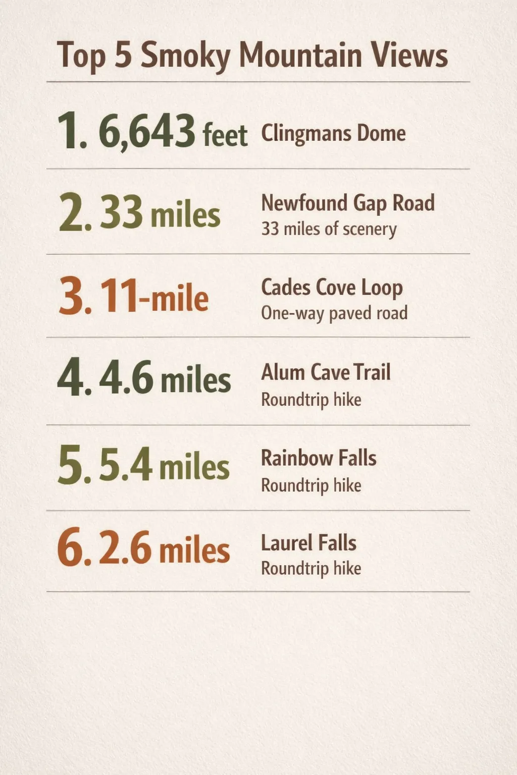 Key view metrics for five routes: Clingmans Dome 6,643 ft; Newfound Gap Road 33 miles; Cades Cove loop 11-mile; Alum Cave Trail 4.6 miles; Rainbow Falls Trail 5.4 miles; Laurel Falls 2.6 miles.
Don’t let the popularity fool you into thinking it’s easy. There are steep, rocky, root-filled sections, and casual walkers regularly turn back early. The insider move: if you’re not feeling the full climb, turn around at Arch Rock for a 2.8-mile roundtrip (9). You still get creek crossings, the rock arch, and solid forest scenery without the steep upper section.
If you want more, Alum Cave is also the standard route up to LeConte Lodge near the 6,593-foot summit of Mt. LeConte - the only in-park lodge, hike-in only, with reservations that book up far in advance.
What to bring: sturdy hiking shoes, 1-2 liters of water per person, a rain jacket, and trekking poles for the rocky upper section (4)(9). Temperatures can swing 20-30°F between the trailhead and the bluffs. Layer.
Rainbow Falls Trail: Tallest Single-Drop Waterfall in the Park
Rainbow Falls Trail runs 5.4 miles roundtrip with about 1,685 feet of elevation gain, rated moderate to strenuous (8). The payoff is the park’s tallest single-drop waterfall - a 80-foot curtain drop that earns its name from the rainbow that forms in the mist on sunny afternoons. Time your visit for late morning to early afternoon when the sun angle is right. If you’re shooting the falls, a polarizing filter cuts the glare off wet rock considerably (8).
Strong hikers can continue all the way to Mt. LeConte from here: a 13-mile roundtrip with roughly 4,000 feet of elevation gain, classified as challenging and a 6-10 hour day (3). Bring real navigation, cold-weather layers, and a headlamp in case you run late.
The trailhead sits on Cherokee Orchard Road near Gatlinburg, a short drive from the Roaring Fork Motor Nature Trail. Easy to pair the two if you want a hike plus a low-effort scenic drive in the same day.
Where to Stay in and Around Great Smoky Mountains National Park
The real choice for where to stay is camping inside the park versus a cabin or hotel in the gateway towns. Inside the park, the only lodge is LeConte Lodge, and reaching it requires a hike.
Camping inside the park - Front-country sites run about $30 per night through Recreation.gov, with no added entrance fee, which keeps a multi-day trip genuinely budget-friendly (2)(7). This is the move if you want dawn and dusk photography without long drives in the dark.
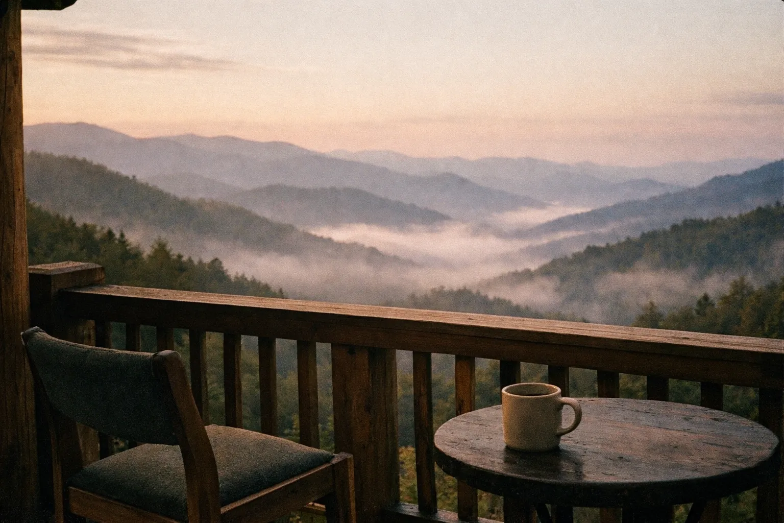
Cabins and hotels in Gatlinburg and Pigeon Forge - Hundreds of options, many with mountain-view decks and hot tubs, generally $150-$400+ per night. Gatlinburg puts you closest to Sugarlands Visitor Center, Roaring Fork, and the road up to Kuwohi/Clingmans Dome. The cabin I stayed in made the early starts easier, which matters more than it sounds when you’re trying to beat traffic at Cades Cove.
One thing most guides get wrong: they tell you to stay in Gatlinburg “for convenience,” but in peak season the town’s traffic can cost you 30-45 minutes just to reach the park entrance. If your trip is built around dawn light at Cades Cove or Kuwohi, camping inside the park eliminates that drive entirely.
Elkmont Campground: Best Basecamp Inside the Smokies
Elkmont Campground - the basecamp most visitors inside the park rely on - has about 200 tent and RV sites with paved driveways and fire rings, reservable through Recreation.gov for around $30 a night (2)(7). According to NPS, reservations open 6 months in advance and the most popular summer and fall dates sell out within hours of release; set a calendar reminder and book the morning your window opens (2). It sits along the Little River, central to Laurel Falls Trail, Newfound Gap Road, and the Elkmont “ghost town.”
That ghost town is the sleeper attraction here. Abandoned cabins line the Little River, and in soft morning light - with far fewer people than Cades Cove - it’s one of the better photo spots in the park (2)(7). If you’re staying at Elkmont, you can walk to it before the day visitors arrive.
Elkmont is also the place for the synchronous fireflies in early June, when thousands of fireflies flash in unison for a couple of weeks. Access runs on a lottery system, so you have to plan months ahead. You cannot just show up at dusk and expect to get in (2).
Wildlife Viewing and Scenic Drives
The park holds roughly two black bears per square mile, one of the densest populations anywhere. You’ll most likely spot them - along with elk - in the open meadows of Cades Cove, Cataloochee Valley, and along Newfound Gap Road at dawn and dusk (6).
Cataloochee Valley is the dedicated elk-viewing spot and the one most guides underplay. The National Park Service reintroduced elk here in 2001, and the herd now numbers around 200 animals (6). The valley sits on the North Carolina side of the park, accessed via a narrow, winding road off I-40 - about 90 minutes from Gatlinburg. It’s worth the drive: Cataloochee gets a fraction of Cades Cove’s traffic, and elk are reliably visible in the open fields at dawn and dusk from September through November during rut. Arrive before sunrise and stay in your vehicle until you’ve scanned the meadow - elk move off into tree cover once foot traffic picks up. According to NPS, the Cataloochee area is one of the best places in the eastern US to observe wild elk behavior up close (6).
Keep your distance. Regulations require staying 50 yards from bears and elk, and rangers actively enforce it in the popular valleys (10). The bear jams in Cades Cove are real: a 2-hour loop can stretch to 4+ hours when someone stops in the middle of the road for a photo.
To beat the worst of it, arrive at the Cades Cove loop entrance at or before 7:00-8:00 a.m. (6)(10). On certain days the loop has bike-and-pedestrian-only hours, which give you unobstructed valley views with no cars at all. The Roaring Fork Motor Nature Trail is a quieter alternative drive - narrow, one-way, and useful when the high overlooks are fogged in.
Map of the Great Smoky Mountains National Park
Cell service inside the park is spotty to nonexistent in most areas. Don’t rely on your phone’s live navigation. Grab a free printed park map at any visitor center - Sugarlands, Oconaluftee, Cades Cove, or Clingmans Dome (1).
Pair the paper map with an offline app like Gaia GPS or AllTrails, downloaded before you lose signal (1)(4)(9). The main artery is Newfound Gap Road (US-441), running north-south from Gatlinburg to Cherokee, with every major overlook signed along the way. The Tennessee side (Gatlinburg entrance) gives you the fastest access to Kuwohi/Clingmans Dome, Laurel Falls, and Alum Cave Trail. The North Carolina side (Cherokee entrance via US-441) puts you closer to Oconaluftee Visitor Center and the Cataloochee Valley turnoff on I-40. If you’re doing a two-day loop, enter from one side and exit the other - Newfound Gap Road connects them in about 45 minutes without stops. Visitor center staff can also tell you which overlooks have clear conditions on a given day - worth a five-minute stop before you drive somewhere only to find it fogged in.
Frequently Asked Questions
- Can I visit the synchronous fireflies without a reservation?
- No, access to the synchronous fireflies at Elkmont requires a lottery reservation booked months in advance.
- Is cell phone service reliable inside Great Smoky Mountains National Park?
- Cell service is spotty to nonexistent in most areas; bring offline maps or printed park maps for navigation.
- Are there any vehicle restrictions on the Cades Cove loop?
- Certain days have bike-and-pedestrian-only hours on the Cades Cove loop, restricting vehicle access for quieter visits.
- What is the best time to see rainbows at Rainbow Falls?
- Late morning to early afternoon on sunny days offers the best sun angle to see rainbows in the mist.
- How early should I arrive at Cades Cove to avoid traffic jams?
- Arrive at or before 7:00-8:00 a.m. to beat heavy traffic and long delays on the Cades Cove loop.
- Can I hike to LeConte Lodge without a reservation?
- No, LeConte Lodge requires advance reservations as it is the only in-park lodge accessible by hike.
A final logistics note: budget for fuel, lodging or camping fees, and a parking tag if you’ll stop longer than 15 minutes anywhere (5). Check the forecast before driving to any high-elevation overlook. Arrive at Cades Cove early. Pick one or two view areas per day rather than racing the whole park.
That last point is the one most people ignore, and it’s the difference between a trip spent in traffic and one spent actually looking at the mountains.